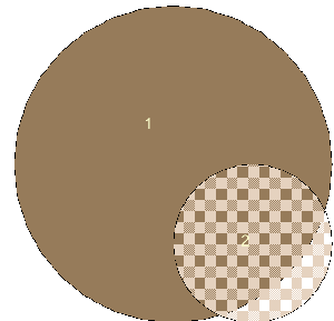
Tuesday, June 03. 2008Spatial DifferencesI've been exploring the PostGIS ST_Difference function. Most OGC compliant spatial databases have this function or a similar one and it behaves more or less the same in all so hopefully this story has implications beyond PostGIS. This is one of those explorations where you metaphorically stare at a function or a stick for that matter and wonder how far can this thing get me with what I know already. It happened with intersections as well until I had exhausted all the uses I could think of for using intersections with what I already knew. Intersections also turned out to be much easier to comprehend than differences. SQL in general is another tool that I use often, but for some reason as simple as SQL is, I haven't quite exhausted all its uses. I suppose because it provides a convenient bus for pushing more complicated function calculations around. Now if only SQL could push function pointers around as easily as it does data I could do more slick things with it. What does ST_Difference do?First there are 2 forms of Differences defined in the OGC specs and PostGIS has both. ST_Difference(geom1,geom2) and ST_SymDifference(geom1,geom2). ST_Difference takes geom1 and subtracts that portion of geom2 that is part of geom1 (the intersection) or as the PostGIS ST_Difference docs say in a more mathematically accurate way Returns a geometry that represents the point set difference of Geometry A with Geometry B. If you are a bitwise groupey - you may prefer the IBM DB2 definition of ST_difference The spatial equivalent of the logical AND NOT (all bits of A AND NOT bits of B) St_SymDifference returns that portion of geom1 and geom2 that does not intersect. In theory, it can be formed with other operations for example ST_Difference(ST_Union(geom1,geom2), ST_Intersection(geom1,geom2)) or ST_Union(ST_Difference(geom1,geom2), ST_Difference(geom2,geom1)) Simple ExampleIf you subtract a polygon that is partially inside another polygon, it is easy to visually imagine what you will get - a polygon, a multipolygon. Example Code and diagram below.
SELECT 1 As gid, g.geom1, g.geom2, ST_Difference(g.geom1, g.geom2) As diff_geom12,
ST_Difference(g.geom2, g.geom1) As diff_geom21,
ST_SymDifference(g.geom1,g.geom2) As diff_symgeom12
INTO diftest
FROM (SELECT ST_Buffer(ST_MakePoint(9,3),2) As geom1,
    ST_Buffer(ST_MakePoint(10,2),1) As geom2) As g;
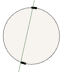
What happens when you subtract a line from a polygon that runs thru the polygon?The result of this in PostGIS surprised me a bit and I think it is wrong, but I'm not sure there is a right answer. I'm not absolutely sure what it should be but just that PostGIS seems to be wrong. To be honest I'm not sure if such a thing has an agreeable visual meaning. To the naked eye what PostGIS returns looks like the original polygon and is still a polygon but it is not the same polygon and placing this under a magnifying glass (the difference between the original polygon and the new one is empty, but the difference between new polygon and the original is some sort of multipolygon thing - which if you think about it is absolutely ridiculous - its like saying your world has gotten slightly bigger by removal of a line). At first I thought what should it return? Should it bisect it or maybe the polygon would just fall apart into a glob of points or lines or maybe it would just be the same polygon. What exactly does it mean to subtract out something that has no area from an area? I have no idea. I know what it means from a mathematical sense - It is the range of points that defines the polygon excluding the range of points that defines the line and if you think about mathematical limits you can see the various parts of the polygon ebbing about the line but never touching it. Unfortunately things possible in calculus just seem to fall apart at the fringes when you try to stuff them into a model that thinks in boundary absolutes and are also hard to visualize when you try to apply normal visual terminology to them. Note the range of points that defines a line is infinite just as the range of points that defines the polygon is infinite, but the polygon is an area range (composed of an infinite number of lines) and the line is a linear range (composed of an infinite number of points).
Below is some code and accompanying diagram for the line that cuts threw the polygon: Code to generate the geometries
SELECT 1 As gid, g.geom1, g.geom2, ST_Difference(g.geom1, g.geom2) As diff_geom12,
ST_Difference(g.geom2, g.geom1) As diff_geom21, ST_SymDifference(g.geom1,g.geom2) As diff_symgeom12
INTO diftest2
FROM (SELECT ST_Buffer(ST_MakePoint(9,3),2) As geom1,
    ST_MakeLine(ST_MakePoint(8,0), ST_MakePoint(10,9)) As geom2) As g;
Below are some simple tests to inspect SELECT ST_Area(geom1) = ST_Area(diff_geom12) As is_areasame,
St_AsBinary(geom1) = St_AsBinary(diff_geom12) As binary_equal,
ST_Equals(geom1,diff_geom12) As spatially_equal,
ST_GeometryType(geom1) As geom1_type,
ST_GeometryType(diff_geom12) As geom12_type
FROM diftest2;
 is_areasame | binary_equal | spatially_equal | geom1_type | geom12_type
-------------+--------------+-----------------+------------+-------------
 t           | f            | f               | ST_Polygon | ST_Polygon
And if we ask how are they different:
SELECT
    ST_AsText(ST_Difference(geom1,diff_geom12)) As diff_geom1_geom12,
   ST_GeometryType(ST_Difference(diff_geom12,geom1)) As diff_geom12_geom1
FROM diftest2;
    diff_geom1_geom12     | diff_geom12_geom1
--------------------------+-------------------
 GEOMETRYCOLLECTION EMPTY | ST_MultiPolygon
Now if you subtract a polygon from a line, and the polygon runs thru the line, then the line no longer has that piece that resided in the polygon and may break into two lines (a MULTILINESTRING) so that is fairly comforting visually although mathematically it is still unappealing at the fringes. This all reminds me of reading a blind programmer's writings and he said something to the effect
I pity those sighted programmers; they have difficulty programming in more than 2 dimensions because their perception of depth is clouded by their vision.. After reading that I realized he was right and my over-reliance on vision cripples my ability to think beyond what I can see.
It made me appreciate just how easily one skill can drown out the others and that it is probably not desirable to sit back idly and allow this to happen.
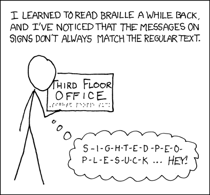
This whole topic of differences also makes me think of this xkcd comic on reading braille Trackbacks
Trackback specific URI for this entry
No Trackbacks
|
Planet PostGISOSGEOCalendar
Categories
|
|||||||||||||||||||||||||||||||||||||||||||||||||||||||