Friday, October 12. 2007Map Dicing and other stuffMap Crushers and SilverlightMy husband, Leo, and I went to the Re-MIX Boston conference recently. They have posted some videos of some of the Boston Re-Mix sessions and more are coming in case anyone wants to see them. On the GIS Microsoft Virtual Earth FrontI attended the Virtual Earth presentation. I didn't get too much out of it that I didn't know already except for 2 points.
On the Silverlight front
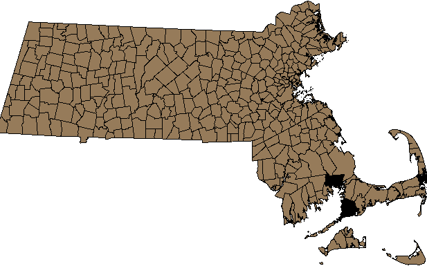
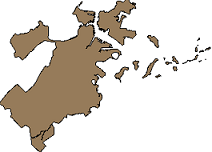
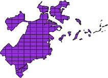
Map Dicing in Spatial Databases: PostGIS ExampleThe Microsoft Virtual Earth presentation did get me thinking about map dicing in spatial databases. Normally when I get maps, I get them on a silver platter - already at the lowest granularity I need. But on rare occasions I would have liked to dice up the data more. Why would you want to do this in a spatial database - particularly PostGIS? For one - the more granular your data, the more generally useful your spatial indexes since they more closely mirror your actual data and also it is speedier for statistical aggregation and doing thematic maps when spatial joining with bigger pieces if you know that your smaller pieces can be fully contained in your larger area of interest. To a point though - at a certain point the over-head of the additional records counteracts the benefits of more useful indexing and also your indexes just become less useful for other reasons. Anyrate, the approach I am about to show may not be the best since its something I thought up in my sleep. The basic approach I would use to dice up say US state boundaries or Massachusetts towns or say census blocks into smaller rectangular quadrants - would be to first create a grid of the extent of the area broken out in even rectangles of x width and y height and then do an intersection with my map of interest to get a new diced map. I will not only dice space - but I shall also pseudo-dice attribute data. I say pseudo because I am going to assume that things like population density etc. are even across each town boundary which we know is not true. For data such as census blocks and depending how low you dice, this assumption may not be so inaccurate. For those not familiar with the wonders of spatial intersection - take a peak at our explanation of ST_Intersection and ST_Intersects complete with sample diagrams. This technique uses OGC standard functions so should work as well with slight variation in syntax in other spatial databases such as Oracle Spatial, IBM DB Spatial Extender, MSSQL Spatial etc. The only part not OGC compliant is my use of the PostgreSQL specific function generate_series, but this can be easily simulated in other databases by creating a dummy table of numbers say from 0 to 10000. The following SQL calls demonstrate this approach. I would be interested in learning how real GIS people do this kind of thing. Step 1 - Get the data of interest and load it - for this I will be using TOWNSSURVEY_POLYM from MassGIS. Step 3 - Make our throw away grid - alas we found a good use for a cartesian product In case it is not quite clear to folks what I am doing here - here it is in simple english Create a reference box starting at the origin of our extent of massachusetts that is of dimension 1485x911 meters - in quasi OGC notation - BOX(xorigin yorigin, (xorigin + 1485) (yorigin + 911)) Next take this box and use it as a paint brush to paint across and then down by translating it hor.n*1485, ver.n*911 Step 4 - Create our final dataset - the towns nicely diced up into smaller rectangler shapes
CREATE TABLE towns_grid
(
  gid serial NOT NULL PRIMARY KEY,
  objectid integer,
  town character varying(21),
  town_id smallint,
  pop1980 integer,
  pop1990 integer,
  pop2000 integer,
  popch80_90 smallint,
  popch90_00 integer,
  "type" character varying(2),
  fourcolor smallint,
  fips_stco integer,
  sum_acres double precision,
  sum_square double precision
);

SELECT AddGeometryColumn('public', 'towns_grid', 'the_geom', 26986, 'MULTIPOLYGON', 2);

--Query returned successfully: 22713 rows affected, 1273117 ms execution time.
INSERT INTO towns_grid(objectid, town, town_id, pop1980, pop1990, pop2000, popch80_90,
       popch90_00, "type", fourcolor, fips_stco, sum_acres, sum_square,
       the_geom)
SELECT objectid, town, town_id,
    pop1980*ST_Area(ST_Intersection(t.the_geom, tg.the_geom))/ST_Area(t.the_geom),
    pop1990*ST_Area(ST_Intersection(t.the_geom, tg.the_geom))/ST_Area(t.the_geom),
    pop2000*ST_Area(ST_Intersection(t.the_geom, tg.the_geom))/ST_Area(t.the_geom),
    popch80_90*ST_Area(ST_Intersection(t.the_geom, tg.the_geom))/ST_Area(t.the_geom),
       popch90_00*ST_Area(ST_Intersection(t.the_geom, tg.the_geom))/ST_Area(t.the_geom), "type", fourcolor, fips_stco, sum_acres*ST_Area(ST_Intersection(t.the_geom, tg.the_geom))/ST_Area(t.the_geom),
    sum_square*ST_Area(ST_Intersection(t.the_geom, tg.the_geom))/ST_Area(t.the_geom),
       ST_multi(ST_Intersection(t.the_geom, tg.the_geom))
  FROM towns t INNER JOIN throwaway_grid tg ON ST_Intersects(t.the_geom, tg.the_geom);

CREATE INDEX idx_towns_grid_the_geom ON towns_grid USING gist(the_geom);
Before and After pictures
Trackbacks
Trackback specific URI for this entry
No Trackbacks
|
Planet PostGISOSGEOCalendar
Categories
|
||||||||||||||||||||||||||||||||||||||||||||||||||||||