Extent Expand Buffer Distance ST_DWithin
In this quick exercise, we will explore the following PostGIS OGC functions: Extent, Expand, Buffer, Distance
Extent
Extent is an aggregate function - meaning that it is used just as you would use SQL sum, average, min, and max often times in conjunction with group by to consolidate
a set of rows into one. Pre-1.2.2 It returned a 2-dimensional bounding box object (BBOX2D) that encompasses the set of geometries you are consolidating.
Unlike most functions in PostGIS, it returns a postgis BBOX object instead of a geometry object.
In some cases, it may be necessary to cast the resulting value to a PostGIS geometry for example if you need to do operations that work on
projections etc. Since a bounding box object does not contain projection information, it is best to use the setSRID function as opposed to simply casting
it to a geometry if you need projection information. SetSRID will automagically convert a BBOX to a geometry and then stuff in SRID info specified in the function call.
Extent3d
Extent has a sibling called Extent3d which is also an aggregate function and is exactly like Extent except it returns
a 3-dimensional bounding box (BBOX3D).
ST_Extent
Starting around version 1.2.2, Extent and Extent3d will be deprecated in favor of ST_Extent . ST_Extent will return a BOX3D object.
Expand (< 1.3.1), ST_Expand (1.2.2 +)
Expand returns a geometry object that is a box encompassing a given geometry. Unlike extent, it is not an aggregate function.
It is often used in conjunction with the distance function to do proximity searches because it is less
expensive than the distance function alone.
The reason why expand combined with distance is much faster than distance alone is that it can utilize gist indexes since it does compares between boxes so therefore reduces the set
of geometries that the distance function needs to check.
Note in versions of PostGIS after 1.2, there exists a new function called ST_DWithin which utilizes
indexes, simpler to write than the expand, &&, distance combination.
ST_Distance will be the preferred name in version 1.2.2 and up
The following statements return equivalent values, but the one using Expand is much faster especially when geometries are indexed and commonly used attributes are indexed.
Find all buildings located within 100 meters of Roslindale
	Using distance and Expand: Time with indexed geometries: 14.5 seconds - returns 8432 records


		SELECT b.the_geom_nad83m
FROM neighborhoods n, buildings b
WHERE n.name = 'Roslindale' and expand(n.thegeom_meter, 100) && b.thegeom_meter
	and distance(n.thegeom_meter, b.thegeom_meter) < 100


	Using distance alone: Time with indexed geometries: 8.7 minutes - returns 8432 records

		SELECT b.the_geom_nad83m
FROM neighborhoods n, buildings b
WHERE n.name = 'Roslindale'
	and distance(n.thegeom_meter, b.thegeom_meter) < 100
ST_DWithin (1.3.1 and above)
We will write the above using the new ST_DWithin to demonstrate how much easier it is.
Using ST_DWithin: Time with indexed geometries: 14.5 seconds - returns 8432 records
SELECT b.the_geom_nad83m
	FROM neighborhoods n, buildings b
		WHERE n.name = 'Roslindale' and ST_DWithin(n.thegeom_meter, b.thegeom_meter, 100)
Within (< 1.3.1), ST_Within (1.3.1 and above)
ST_Within(A,B) returns true if the geometry A is within B. There is an important distinction between
Within and ST_Within and that is the ST_Within does an implicit A&&B call to utilize indexes where as Within and _ST_Within do not.
1.3.1 and above do
SELECT b.the_geom_nad83m
	FROM neighborhoods n, buildings b
		WHERE n.name = 'Roslindale' and ST_Within(b.thegeom_meter, n.thegeom_meter)
Pre 1.3.1 do
SELECT b.the_geom_nad83m
	FROM neighborhoods n, buildings b
		WHERE n.name = 'Roslindale' and b.thegeom_meter && n.thegeom_meter AND Within(b.thegeom_meter, n.thegeom_meter)
ST_Buffer (+1.2.2), Buffer (< 1.2.2)
Buffer returns a geometry object that is the radial expansion of a geometry expanded by the specified number of units. Calculations are in units of the Spatial Reference System of this Geometry.
The optional third parameter sets the number of segments used to approximate a quarter circle (defaults to 8) if third argument is not provided.
This is a much more involved process than the expand function because it needs to look at every point of a geometry whereas the expand function only looks at the bounding box of a geometry.
Aliases: ST_Buffer (MM-SQL)
Correcting Invalid Geometries with Buffer
Buffer can also be used to correct invalid geometries by smoothing out self-intersections. It doesn't work for all invalid geometries, but works for some.
For example the below code will correct invalid neighborhood geometries that can be corrected. Note in here I am also combining the use with
MULTI since in this case buffer will return a polygon and our table geometries are stored as multi-polygons. If your column geometry is a POLYGON rather than a MULTIPOLYGON then you can leave out the MULTI part.
	UPDATE neighborhoods
		SET the_geom = multi(buffer(the_geom, 0.0))
		WHERE isvalid(the_geom) = false AND isvalid(buffer(the_geom, 0.0)) = true
Pictorial View of Buffer, Expand, Extent
In this section we provide a graphical representation of what the operations Buffer, Expand, Extent look like when applied to geometries.
Legend
 |
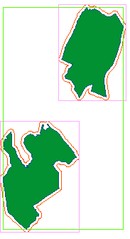 |
Corresponding Queries
Original: SELECT the_geom, name
FROM neighborhoods
WHERE name IN('Hyde Park','Roxbury')
Expand: Draws a box that extends out 500 units from bounding box of each geometrySELECT expand(the_geom, 500) as geom, name
FROM neighborhoods
WHERE name IN('Hyde Park', 'Roxbury')
Extent: Draws a single bounding box around the set of geometriesSELECT extent(the_geom) as thebbox, name
FROM neighborhoods
WHERE name IN('Hyde Park', 'Roxbury')
Buffer: Extends each geometry out by 500 units. SELECT buffer(the_geom,500) as geom, name
FROM neighborhoods
WHERE name IN('Hyde Park', 'Roxbury')
|
Post Comments About Extent Expand Buffer Distance: PostGIS - ST_Extent, Expand, ST_Buffer, ST_Distance

